The invisible problem: driving a license-free car with a classic GPS
Every day, thousands of license-free car drivers open Waze or Google Maps to get to work, do their shopping or visit relatives. This harmless gesture hides a problem only license-free car drivers know: these apps have no idea you are driving at 45 km/h maximum.
The result? Dangerous routes, fanciful arrival times and constant stress on every trip. If you drive a Citroën Ami, an Aixam or a Ligier, you have surely lived through this situation at least once.
Why Waze and Google Maps are dangerous in a license-free car
Routes designed for regular cars
Waze and Google Maps calculate the fastest route based on an average speed of 50 to 130 km/h depending on the road type. When the algorithm sends you onto an expressway limited to 90 km/h, it assumes you will drive at that speed. In a license-free car, you drive there at 45 km/h, half as fast as the flow of traffic.
It is exactly like sending a bicycle onto a motorway. Except here, the other drivers do not expect to meet you at that speed. Sudden overtaking, blaring horns and near-miss situations become a daily reality.
Expressways and ring roads: a real danger
In France, many urban areas are built around ring roads and expressways. Bordeaux, Toulouse, Rennes, Nantes: in all these cities, the classic GPS will naturally favor these fast arteries. Yet driving at 45 km/h on a ring road where traffic flies by at 90 km/h is putting yourself in mortal danger.
And the problem is not limited to the big ring roads. The 80 km/h departmental roads, the no-overtaking zones where cars grow impatient behind you, the access ramps too short to merge safely: the risky situations are everywhere.
The “avoid motorways” option fixes nothing
Many license-free car drivers know this trick: tick “avoid motorways” in the settings of Waze or Google Maps. But this option falls well short, and here is why:
- It only avoids motorways in the strict sense (blue signs). Expressways, ring roads and dual carriageways limited to 90 or 110 km/h are not filtered out.
- It does not know the roads forbidden to license-free cars. Some arteries are explicitly forbidden to vehicles limited to 45 km/h, but no mainstream GPS knows this.
- The ETAs stay wrong. Even on secondary roads, the GPS calculates your travel time based on a speed of 50 km/h in town and 80 km/h outside built-up areas. You arrive late every time.
Completely wrong travel times
This is perhaps the most frustrating problem day to day. Your GPS shows 20 minutes, you take 35. It announces 45 minutes, count on 1h15. This difference is not trivial: it disrupts your day, makes you late for work, makes you miss appointments.
The reason is mathematical. On a mixed city/country trip, a classic GPS estimates an average speed around 55-60 km/h. In a license-free car, your real average is around 35-40 km/h (45 km/h max, less in town, at lights, in roundabouts). That is a gap of 40 to 50% on every trip.
What license-free car drivers really need
A GPS that knows the limits of the license-free car
A good GPS for a license-free car must build in, natively, the fact that your vehicle does not exceed 45 km/h. Not as an option hidden in a menu, but as the very foundation of the route calculation. That means:
- Automatically excluding all roads that are dangerous or forbidden to license-free cars (motorways, expressways, 90+ km/h dual carriageways)
- Favoring suitable roads: quiet departmental roads, local roads, 30 and 50 zones
- Calculating realistic ETAs based on a real speed of 45 km/h maximum
Guidance designed for slow driving
When you drive at 45 km/h on an 80 road, you need guidance that anticipates. Turns, intersections and direction changes must be announced at the right moment for your speed, not for a motorist driving twice as fast. Voice guidance must be designed for your reality as a slow driver, not for a classic motorist.
TacTac: the GPS designed exclusively for license-free cars
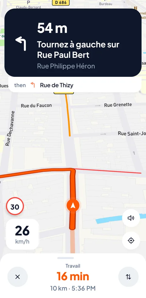
It is precisely to meet these needs that we created TacTac. Rather than adapting a general-purpose GPS, we built a navigation system entirely designed for license-free cars.
Truly suitable routing
The TacTac navigation engine uses a license-free car specific routing profile. In concrete terms, this means the app natively excludes all roads where a license-free car has no business being. No fiddling in the options, no box to tick: as soon as you launch a route, it is calculated for your vehicle.
ETAs that are finally reliable
TacTac calculates your travel times based on 45 km/h maximum. When the app tells you 25 minutes, you arrive in 25 minutes. This reliability changes daily life: you can finally plan your days without systematically adding a 50% margin.
Voice guidance calibrated for 45 km/h
TacTac’s voice guidance is designed for license-free cars: turn announcements arrive at the right moment for your speed, neither too early nor too late. The instructions are clear, simple and suited to the reality of driving at 45 km/h. To learn more about insuring your license-free car or the mandatory technical inspection, see our dedicated guides.
In short
| Feature | Classic GPS | TacTac |
|---|---|---|
| Avoids expressways | Partially | Yes, natively |
| ETA based on 45 km/h | No | Yes |
| Roads forbidden to LF cars cut | No | Yes |
| Voice guidance suited to LF car | No | Yes |
If you drive a license-free car, using a classic GPS is not just an inconvenience, it is a risk. Whether you drive a Citroën Ami, Aixam or Ligier, whether your license-free car is combustion or electric, you deserve a GPS that understands your vehicle.
Join the TacTac waitlist and be among the first to navigate safely.